Global Radar 
WORLD RADAR IMAGES
Global Radar Archive 
ARCHIVED IMAGES
Precipitype 
CURRENT RAIN/SNOW
Radar 
LATEST RADAR IMAGES
Radar Archive 
ARCHIVED IMAGES
Settling Snow Radar 
MELT OR SETTLE?
Storm Radar 
STORMS POSSIBLE?
Tornado Radar 
TORNADOES POSSIBLE?
Upwind Rainfall 
RAIN UPWIND OF YOU
Wind Radar 
WET N WINDY
Airmass 
AIRMASS SATELLITE IMAGES
Cloud Height Satellite 
HOW HIGH IS THAT?
Cloud Type Satellite 
FLUFFY OR NOT?
Fog Satellite 
FOGGYSAT
Global Satellite 
WORLD SATELLITE IMAGES
IR Satellite 
HI RES IR SATELLITE
Satellite Archive 
ARCHIVED IMAGES
Snow Satellite 
SPACE LAMPPOSTS
Storm Satellite 
THUNDERSTORM SATELLITE
Visible Satellite 
HI RES VISIBLE SATELLITE
Water Vapour Satellite 
HI RES WV SATELLITE
CycloneTracker 
TRACK ATLANTIC CYCLONES
Hurricane Centre 
LATEST ATLANTIC HURRICANES
Hurricane Hunters 
LIVE DATA
Live Aeroplane Data 
LIVE AMDAR DATA
Live Weather Map 
LIVE WEATHER PLOTTED ON A MAP
METAR/TAF 
AIRPORT WEATHER
Observation Archive 
ARCHIVED DATA
Rainfall Archive 
DID IT RAIN?
StormTracker 
THUNDERSTORM TRACKER LIVE
WeatherCams 
EYE SPY
Lightning Archive 
ARCHIVED DATA
Lightning Strikes 
LIVE LIGHTNING STRIKES
Past Hour Lightning 
LAST HOUR
Yesterdays Global Lightning 
BANG! CRASH!
Aurora Forecast 
NORTHERN LIGHTS
Latest Sun Image 
BIG YELLOW BALL
Space Station Passes 
TIMES/WEATHER ISS
Sun/Moon Times 
SUN/MOON TIMES AND PHASES
FogScanner 
PLAY MISTY FOR ME
GaleScanner 
BIT BLOWY
Rain Scanner 
RISK OF RAIN
Snow Scanner 
RISK OF SNOW
Storm Scanner 
RISK OF STORMS
Above Me Now 
WHERE EAGLES FLY
Atlantic Storms 
OUR STORM NAMES
Freezing Level 
SHOWING SNOW/RAIN LEVEL
GDAS Observations 
GFS MODEL OBS DATA
Metcheck CET 
CENTRAL ENGLAND TEMPERATURE
Teleconnections 
NAO/AO ETC


Chance Of Clear Skies 
MOON AND STARS?
Clear Air Turbulence 
BUMPY LANDINGS?
Frost Maps 
LATEST FORECASTS FOR FROST/ICE
GHX Risk Charts 
RISK OF RAIN MAPS
GHX Risk Charts Ext 
30 DAY RISK MAPS
Haines Index Charts 
WILDFIRE RISK
Humifeel Charts 
HOT AND SWEATY?
Probability Charts 
557WW PROBABILITIES
Snow Maps 
RAIN OR SNOW?
Storm Maps 
THUNDERSTORMS EXPECTED?
UV Index Forecast 
SLIP SLOP SLAP
Visibility Charts 
MIST/FOG
Weather Alarm Global 
HIGH RES ADVERSE WEATHER
Weather Alarm Regional 
HIGH RES ADVERSE WEATHER
Weather Charts Archive 
ARCHIVED CHARTS
Weather Icon Charts 
ICON BASED CHARTS
Air Quality/Pollen 
ATCHOO! COUGH!
Calendars 
ADD FORECASTS TO CALENDARS
Climatic Deviation 
WARMER OR COLDER?
Cloudwatch 
CLOUD CROSS SECTION
Ensemble Data 
MODEL ENSEMBLES
Ensemble Risk 
RISK OF RAIN ETC
Ensemble Risk Ext 
30 DAY RISK OF RAIN ETC
Global Forecasts 
GLOBAL FORECASTS
Laundry Drying 
PANTS REALLY...
Next Month 
NEXT MONTH OUTLOOK
Pollen Type Forecasts 
TREE AND GRASS POLLEN
Skew-T Forecasts 
ATMOSPHERIC PROFILES
Snowwatch 
SNOW FORECAST DATA
Stormwatch 
STORM FORECAST DATA
The Week Ahead 
WEEK AHEAD AVERAGES
The Year Ahead 
UK SINGULARITIES
When Will It Next 
MODEL SCANNER


ARCUS 
SUPER ENSEMBLE CHARTS
ARPEGE 
METEO FRANCE
BAM 
BAM MODEL FROM CPTEC IN BRAZIL
ECMWF 
EURO MODEL
GEM 
CANADIAN MODEL
GFS 
NCEP GFS MODEL
GFS Animated 
GFS ANIMATED
GFS Archive 
ARCHIVED CHARTS
Global Model Verification 
PREVIOUS FORECASTS FOR TODAY
ICON 
DWD MODEL
JMA 
JAPANESE MET AGENCY
NASA GEOS5 
NASA MODEL
NAVGEM 
NAVGEM
SL-AV Model 
RUSSIAN MODEL
ALADIN 
METEO FRANCE FOR UK
ALARO 
BELGIAN RMI MODEL
ARCUS UK 
UK SUPER ENSEMBLE
Arome 
METEO FRANCE FOR UK
Arome Caribbean 
METEO FRANCE FOR CARIBBEAN
Arome Indian Ocean 
HI RES FOR MAURITIUS
Arpege 
METEO FRANCE FOR EUROPE
GFS Regional 
HI RES PLUS DATA
HRRR 
NCEP FOR USA
ICON 
DWD MODEL
ICON D2 
DWD HI RES MODEL
NAM 
NCEP FOR USA
RAP Model 
NCEP FOR USA
RDPS Model 
CANADIAN MODEL
UK RAP Model 
NCEP HI RES MODEL
ECMWF Wave 
ECMWF WAVE
EMFWAM 
METEO FRANCE EUROPE
EWAM 
DWD EUROPE
GMFWAM 
METEO FRANCE GLOBAL
GWAM 
DWD GLOBAL
GWVE 
GFS GLOBAL
Sea Temperatures 
TEMPERATURES + ANOMALY
557WW Ensembles 
ENSEMBLE AVERAGES
CFS Ensembles 
ENSEMBLE AVERAGES
ECMWF Ensembles 
ENSEMBLE AVERAGES
GEM Ensembles 
ENSEMBLE AVERAGES
GFS Ensembles 
ENSEMBLE MODEL DATA
ICON D2 Ensembles 
HIGH RES ENSEMBLES
ICON Ensembles 
ENSEMBLE AVERAGES
ICON Europe Ensembles 
EUROPEAN ENSEMBLES
CanSIPS Seasonal 
SEASONAL CHARTS
CFS Seasonal Charts 
6 MONTH FORECASTS
Long Range Charts 
SUPER LONG RANGE WEATHER
Hurricane Models 
HI RES FLOATER MODEL
Tropical Weather Models 
TROPICAL MODEL OUTLOOK
Air Quality/Pollen Charts 
ATCHOO!
Dust Charts 
DUST/AEROSOL CHARTS
Jet Stream 
NCEP GFS JET STREAM
Jet Stream Archive 
ARCHIVED CHARTS
Stratosphere Forecasts 
UPPER AIR CHARTS
Synoptic Charts 
FRONTS AND ISOBARS


Forecast Challenge 
CHALLENGE US
Gallery 
USER PICTURE GALLERY
MyMetcheck 
MYMETCHECK
Weather Reports 
YOUR WEATHER REPORTS


Add Club Location 
ADD YOUR CLUB LOCATIION TO OUR DATABASE
Astronomy 
STARRY STARRY NIGHTS
Aviation 
UP UP AND AWAY
Camping 
CAMPING IT UP
Canoeing 
ESKIMO ROOOOLL
Climbing 
AFRAID OF HEIGHTS?
Cricket 
HOWZAT!
Croquet 
CROQUET WEATHER FORECASTS
Cycling 
I LOVE TO RIDE MY...
Diving 
DEEP BREATH
Fishing 
CHANCE OF A CATCH
Gardening 
PRUNING WEATHER
Golf 
HOLE IN ONE
Horse Riding 
GIDDY UP!
Jogging 
JOGGING WEATHER
Kiteboarding 
COAST WEATHER
Model Aviation 
MODEL AVIATION / ROCKET FORECASTS
Mountain Biking 
MOUNTAIN FORECASTS
Mountains & Hills 
MOUNTAIN RANGES
Paragliding 
WHERE EAGLES FLY
Polo 
HORSEY WEATHER
Rambling/Walking 
WEATHER FOR RAMBLING AND WALKING
Rowing 
LAKE WEATHER
Sailing 
INSHORE FORECASTS
Skydiving 
UPPER AIR FORECASTS
Surfing 
BEACH BREAK FORECASTS
Tennis 
TENNIS FORECASTS
Windsurfing 
BEACH FORECASTS
Air Shows 
FLY PASSES
Firework Displays 
BANG! WHOOSH! WEEE!
Royal Shows 
BULLS AND ROSETTES
Weekend Attractions 
WEEKEND ATTRACTIONS
Festivals 
ALL OUR FESTIVALS
Formula 1 
WEATHER FOR F1 RACES
Formula 1 E 
WEATHER FOR F1E RACES
MotoGP 
WEATHER FOR MOTOGP
Red Arrows Displays 
WHERE ARE THEY NEXT?
Red Arrows Live 
ROGER ROGER TANGO
Rugby Union 
RUGBY WEATHER
UK Football Leagues 
PREMIER ETC
World Football Leagues 
MORE FOOTBALL
Champions League 
EVERY MATCH FORECAST
Europa Conference 
EVERY MATCH FORECAST
Europa League 
EVERY MATCH FORECASTS
Horseracing 
FORECASTS AND CALENDAR
IPL Cricket 
HOWZAT!
UEFA Nations League 
CMON ENGLAND!
Arc de Triomphe 
ARC DE TRIOMPHE WEATHER
Breeders Cup 
BREEDERS CUP WEATHER
Champions Day Ascot 
CHAMPIONS DAY ASCOT WEATHER
Cricket World Cup 
CRICKET WORLD CUP WEATHER
Darts - Lakeside 
DARTS - LAKESIDE WEATHER
Rugby Union World Cup 
RUGBY UNION WORLD CUP WEATHER
Ryder Cup 
RYDER CUP WEATHER
Solheim Cup 
SOLHEIM CUP WEATHER


Discussion Archive 
ALL OUR OLD DISCUSSIONS
Discussions 
METEOROLOGISTS DISCUSSIONS
Event Discussions 
METEOROLOGISTS DISCUSSIONS
Eye In The Sky 
HI RES SATELLITE STUFF
Eye In The Sky Archive 
LOADSA IMAGES
Frontpage Archive 
ALL OUR RAMBLINGS
GFS Commentary 
METEOROLOGISTS LIVE DISCUSSIONS
Global Discussions 
AROUND THE WORLD
Global Discussions Archive 
AROUND THE WORLD
Live Daily Feed 
LATEST WEATHER INFO
Live Discussions 
EXPERT IMAGE ANALYSIS
Snow Discussion 
OFFICIAL FORECAST
Snow Discussion Archive 
OLD SNOW DISCUSSIONS
Storm Discussion 
METEOROLOGISTS STORM DISCUSSIONS
Storm Discussion Archive 
OLD STORM DISCUSSIONS


Construction 
CRANES/CEMENT
Developers 
FREE DATA
Electricity Demand 
HDD/CDD
Farming 
FARMING FORECASTS
GHX Model 
OUR WEATHER MODEL
Retail Demand 
SALE NOW ON!
Weather Stickies 
WEATHER ON YOUR SITE


Search Metcheck


Pages Now Trending

Visit ►
Radar Latest Radar Images
Discussions Meteorologists Discussions
Aurora Forecast Northern Lights
Global Radar World Radar Images
GFS Ncep Gfs Model
◄► Next Month Next Month Outlook
◄► Lightning Strikes Live Lightning Strikes
Weather Reports Your Weather Reports
◄► Weather Icon Charts Icon Based Charts
◄► Easter Discussions Meteorologists Discussions

Other Section Pages

- Aurora Forecast 

    Northern Lights

- Latest Sun Image 

    Big Yellow Ball

- Space Station Passes 

    Times/Weather ISS

- Sun/Moon Times►  

    Sun/Moon Times►  and Phases

Moonrise, Moonset and Moon Phase for Breglum

Date Moonrise (Local Time) Moonset (Local Time) Phase Illumination Distance
Wednesday 24 April 2024 21:26 09:06 99% 398849km
Thursday 25 April 2024 22:14 09:52 98% 394951km
Friday 26 April 2024 23:06 10:42 95% 390537km
Saturday 27 April 2024 00:03 11:36 89% 385837km
Sunday 28 April 2024 01:02 12:35 82% 381093km
Tuesday 30 April 2024 02:03 14:35 62% 372448km
Wednesday 1 May 2024 03:01 15:32 51% 368994km
Thursday 2 May 2024 03:57 16:26 39% 366369km
Friday 3 May 2024 04:51 17:18 28% 364708km
Saturday 4 May 2024 05:41 18:08 18% 364098km
Sunday 5 May 2024 06:31 18:58 10% 364570km
Monday 6 May 2024 07:20 19:48 4% 366099km
Tuesday 7 May 2024 08:12 20:40 0% 368608km
Wednesday 8 May 2024 09:05 21:35 0% 371965km
Thursday 9 May 2024 10:00 22:32 1% 375996km
Friday 10 May 2024 10:58 23:30 6% 380494km
Saturday 11 May 2024 11:57 00:28 12% 385226km
Sunday 12 May 2024 12:53 01:22 19% 389945km
Tuesday 14 May 2024 14:36 02:13 38% 398385km
Wednesday 15 May 2024 15:21 03:01 47% 401669km
Thursday 16 May 2024 16:02 03:44 57% 404090km
Friday 17 May 2024 16:43 04:24 66% 405522km
Saturday 18 May 2024 17:20 05:04 74% 405892km
Sunday 19 May 2024 17:59 05:42 82% 405180km
Monday 20 May 2024 18:40 06:21 89% 403424km
Tuesday 21 May 2024 19:21 07:02 94% 400714km
Wednesday 22 May 2024 20:07 07:46 97% 397190km
Thursday 23 May 2024 20:57 08:34 99% 393035km
Friday 24 May 2024 21:53 09:27 99% 388464km
Saturday 25 May 2024 22:51 10:23 97% 383714km
Sunday 26 May 2024 23:51 11:23 92% 379031km
Monday 27 May 2024 00:50 12:23 85% 374657km
Tuesday 28 May 2024 01:47 13:20 76% 370818km
Thursday 30 May 2024 02:41 15:08 55% 365503km
Friday 31 May 2024 03:32 16:00 43% 364303km
Saturday 1 June 2024 04:22 16:49 31% 364174km
Sunday 2 June 2024 05:11 17:38 21% 365124km
Monday 3 June 2024 06:02 18:30 12% 367102km
Tuesday 4 June 2024 06:55 19:24 5% 370008km
Wednesday 5 June 2024 07:50 20:20 1% 373689km
Thursday 6 June 2024 08:48 21:19 0% 377956km
Friday 7 June 2024 09:46 22:17 1% 382588km
Saturday 8 June 2024 10:44 23:14 4% 387344km
Sunday 9 June 2024 11:39 00:07 9% 391979km
Monday 10 June 2024 12:30 00:56 15% 396253km
Tuesday 11 June 2024 13:16 01:40 23% 399945km
Thursday 13 June 2024 14:40 02:22 41% 404855km
Friday 14 June 2024 15:19 03:02 50% 405820km
Saturday 15 June 2024 15:57 03:40 59% 405708km
Sunday 16 June 2024 16:37 04:18 68% 404523km
Monday 17 June 2024 17:17 04:59 77% 402327km
Tuesday 18 June 2024 18:01 05:41 84% 399234km
Wednesday 19 June 2024 18:50 06:27 91% 395405km
Thursday 20 June 2024 19:43 07:18 95% 391037km
Friday 21 June 2024 20:40 08:13 98% 386356km
Saturday 22 June 2024 21:39 09:11 99% 381605km
Sunday 23 June 2024 22:39 10:11 98% 377030km
Monday 24 June 2024 23:36 11:09 94% 372868km
Tuesday 25 June 2024 00:31 12:06 88% 369333km
Wednesday 26 June 2024 01:23 13:00 79% 366610km
Friday 28 June 2024 02:13 14:40 58% 364112km
Saturday 29 June 2024 03:02 15:29 46% 364466km
Sunday 30 June 2024 03:53 16:20 34% 365883km
Monday 1 July 2024 04:45 17:13 24% 368290km
Tuesday 2 July 2024 05:39 18:09 14% 371562km
Wednesday 3 July 2024 06:36 19:07 7% 375530km
Thursday 4 July 2024 07:35 20:07 3% 379988km
Friday 5 July 2024 08:34 21:05 0% 384706km
Saturday 6 July 2024 09:30 22:00 0% 389438km
Sunday 7 July 2024 10:23 22:50 2% 393942km
Monday 8 July 2024 11:11 23:36 6% 397982km
Tuesday 9 July 2024 11:56 00:19 11% 401350km
Wednesday 10 July 2024 12:38 01:00 18% 403872km
Thursday 11 July 2024 13:17 01:38 26% 405416km
Saturday 13 July 2024 14:34 02:16 43% 405310km
Sunday 14 July 2024 15:14 02:56 53% 403664km
Monday 15 July 2024 15:57 03:37 62% 401052km
Tuesday 16 July 2024 16:44 04:21 71% 397609km
Wednesday 17 July 2024 17:34 05:10 80% 393513km
Thursday 18 July 2024 18:30 06:04 87% 388976km
Friday 19 July 2024 19:27 07:01 93% 384234km
Saturday 20 July 2024 20:27 08:00 97% 379531km
Sunday 21 July 2024 21:25 08:58 99% 375112km
Monday 22 July 2024 22:21 09:55 99% 371204km
Tuesday 23 July 2024 23:13 10:50 96% 368011km
Wednesday 24 July 2024 00:04 11:41 90% 365697km
Thursday 25 July 2024 00:54 12:31 82% 364383km
Friday 26 July 2024 01:44 13:20 72% 364136km
Sunday 28 July 2024 02:35 15:03 49% 366839km
Monday 29 July 2024 03:28 15:59 37% 369650km
Tuesday 30 July 2024 04:25 16:56 27% 373255km
Wednesday 31 July 2024 05:23 17:55 17% 377468km
Thursday 1 August 2024 06:23 18:55 10% 382072km

Help & Information

New Today On Metcheck

1 NEW frontpage article
- Fewer Showers

1 NEW weather warning
Read ►

1 NEW discussion
- Read ►

1 NEW global discussion
- Read ►

2 NEW EASTER discussions
- Read ►

1 NEW live discussion
- Read ►

31 NEW weather reports
- Read/Add ►

1 NEW snow discussion
- Read ►

March ends with low pressure to the Southwest which brings in some interesting weather systems...

Added : 3 hours ago

Sunshine and showers across the UK and Ireland, unsettled conditions for the Canary Islands and Tropical Cyclone Neville...

Added : 23 hours ago

Blustery showers continue across the North and Northeast this morning as the wind starts to die down across Eastern areas...

Added : 8 hours ago

Want to see where precipitation is dropping out of the sky right now across the UK? No worries, check out the 15 minute radar below which loops through the last 6 hours of information.

Toys Similar To This :-

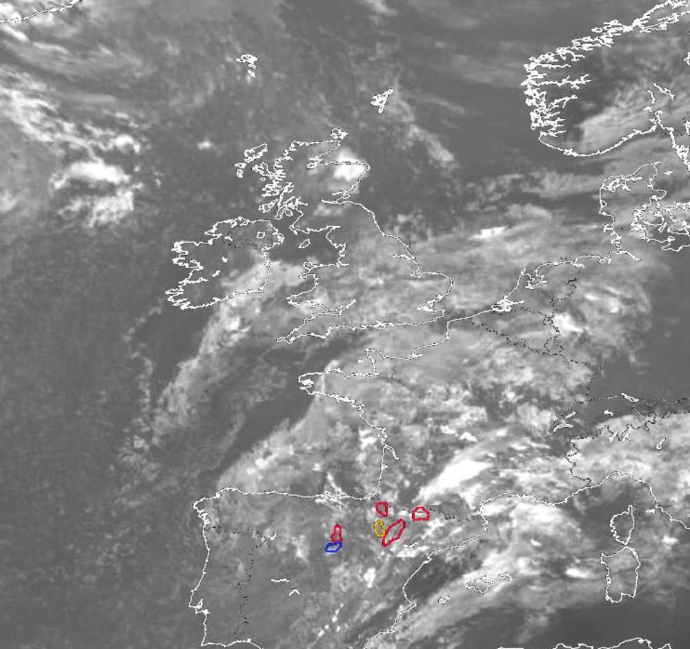
Whoah! How clever is this? The Metcheck Thunderstorm Tracker Satellite allows you to see the developing storms across Western Europe and tells you whether they are growing or decaying. Every 15 minutes we take a snapshot of the cloud cover then measure the temperature and height of the clouds and show you whether the area of clouds are developing into thunderstorms and what direction they are moving in.

Toys Similar To This :-

Live weather data from around the country displayed on Google Maps

Toys Similar To This :-

These are the latest NCEP GFS model weather charts at Metcheck.

Toys Similar To This :-

You probably hear a lot about the Jet Stream in the news. It's either too far North or too far South. The jet stream is identified as winds at 300mb (during Winter) and 200mb (during Summer). It is these winds which are responsible for driving and developing weather systems across the Atlantic.

Metchecks own GHX model charts out to 240 hours ahead

Toys Similar To This :-

The Metcheck 7 Day Forecast takes the best from the GFS weather models and displays it in easy to read maps for the UK out to the next 192 hours ahead.

The Metcheck 7 Day Forecast takes the best from the GFS weather models and displays it in easy to read maps for the world out to the next 192 hours ahead.

Showing you where frost and ice is expected to develop out to 16 days ahead.

Toys Similar To This :-

Pages Now Trending

Visit ►
Radar Latest Radar Images
Discussions Meteorologists Discussions
Aurora Forecast Northern Lights
Global Radar World Radar Images
GFS Ncep Gfs Model
◄► Next Month Next Month Outlook
◄► Lightning Strikes Live Lightning Strikes
Weather Reports Your Weather Reports
◄► Weather Icon Charts Icon Based Charts
◄► Easter Discussions Meteorologists Discussions